Showing posts sorted by relevance for query lrx. Sort by date Show all posts

Friday, March 15, 2019

February 2019 LRX Public Meeting Comments

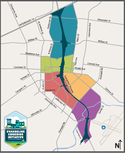
The comments below were submitted on March 15, 2019. The February public meeting that solicited these comments presented the Tier 1 Environmental Impact Study for the Lafayette western bypass termed the Lafayette Regional Xpressway or simply the LRX. Learn more about the meeting and the LRX by reading the recent Connector Comments meeting announcement. It is available by clicking HERE.

The period for public comments closes on March 18, so you may still have time to submit your statement of support, concerns, or questions. Although the attached comment is quite detailed, short comments simply stating support and/or concerns are of great value and provide evidence of public interest.

The meeting slide show included this information on how to provide written comments after the meeting:
  • Send comments to: HNTB Corporation,10000 Perkins Rowe, Suite 604, Baton Rouge LA 70810,
  • or, Email comments to kbprejean@hntb.com
  • Comments received or postmarked by March 18, 2019 will become a part of the record.

If you have submitted or do submit comments through one of these methods, please consider sharing your comments with us by pasting then in the comments section at the end of this article. However, do be aware that comments on this Connector Comments site are not official, so be sure to submit official comments as described in the bullets above.


__________________________________________________________

Comments of Michael G. Waldon, PhD
Following LRX Public Meeting February 28, 2019


The following comments are my comments submitted in response to the request for public comments at the Public Hearing held in Lafayette on February 28, 2019.
I have divided my comments into the following topic-related sections.

Statement of appreciation
Relationship to other projects and needed model scenarios
Where is the Eastern Corridor?
Arkansas example - phased funding and completion
Flooding
Preferred corridor selection
Public information and participation
Public support
2005 Study Corridor Map


Statement of appreciation

I first sincerely thank the LMEC for holding this hearing and giving the public an opportunity to share our support and concerns. Thanks is also due to the visionary citizens of Lafayette who saw almost two decades ago that the only viable path forward for a north-south interstate connecting I-49 segments was a bypass. At that time, the so-called I-49 Connector, the “Con,” was seen to be effectively dead; killed by fierce public opposition, environmental infeasibility, and legal challenges. And rightfully so.


Relationship to other projects and needed model scenarios

If we cannot call the LRX an alternative to the I-49 Con, then at least allow us to call it a substitute.

Although our Louisiana DOTD continues to waste many tens of millions of federal tax dollars on planning the I-49 Con, it is even less viable today than in the early 2000s when it was effectively abandoned. Today’s advancements in geochemical science provide an even better understanding of the environmental risk of further contamination of the Chicot aquifer, and there is a renewed concern for flooding since the 2016 regional flood disaster. Additionally, the massive negative impact of urban interstates, particularly on poor and minority communities has become even more apparent than it was  decades ago. The Con is today quite simply inviable (i.e. dead). For years the LRX plans were stalled in order to not “distract” the public with the promise of a substitute for the locally opposed Con. Let us delay no longer. The LRX is our most advanced proposed substitute for the failed Con, and I urge our professional, political, and civic leaders to now give its development their enthusiastic support. Lafayette does urgently need the LRX project. Although completion of the LRX may be far in the future, every distraction coming from the Con, and every other delay simply moves LRX completion further into that future.

If ever built, the I-49 Con is almost certain to be partially toll funded (https://connectorcomments.blogspot.com/2016/06/the-specter-of-tolls-on-i-49-connector.html). Former Secretary of Transportation Dr. Kam Movassaghi was quoted (The Independent, April 14, 2009) saying that tolls must be considered for funding I-49 construction. An expert speaking to a meeting sponsored by our Chamber of Commerce affiliate One Acadiana (The Advocate, October 22, 2015) suggested that a toll of $0.19 per mile might be used to fund I-49 completion, and an Advocate article (September 22, 2014) reported that a state funded feasibility study looked at $0.18 per mile for I-49 funding. Former State Senator and then I-49 South Coalition Director, Mike Michot, was quoted in that same article saying about I-49 South "It seems unlikely a project of that magnitude will be built without the help of toll dollars."

The infeasibility of building the I-49 Con project is highly relevant in planning for the LRX, as is the prospect of the Con also having tolls. Additional model scenarios need to be considered for LRX planning. First, the scenario that the I-49 Con will never be constructed needs to be considered as a scenario because this is in fact most likely. Second, the scenario that the I-49 Con is built but has tolls must be considered. Adding tolls to the I-49 Con in modeling will increase traffic flow and toll revenue of the LRX. Failure to include these added scenarios related to the future I-49 Con seriously impairs planning for LRX traffic and toll revenue. Failure to consider these scenarios could negatively impact Louisiana's financial negotiations in dealing with the private PPP project partner for the LRX. 

It seems relevant to mention here that despite the tens of millions of dollars already spent on I-49 Con planning, to-date the DOTD has refused to include an I-49  toll scenario, or to incorporate the LRX in any I-49 Con traffic models. To members of the public this appears to be a blatant attempt to inflate traffic projection to thus justify the Con project. This concern is relevant here because I hope that such manipulation of planning results is not a part of the LRX project. A refusal to run the added scenarios listed here would lead to a similar but opposite appearance. It would lead the public to think that the LMEC and DOTD are purposefully failing to consider scenarios in order to “put their finger on the scale” giving preference to the Con relative to the LRX substitute.

In summary of my concerns stated in this section, I am asking that two LRX planning scenarios (model runs) be added for projection of traffic and toll revenue. First, projections are needed for the most likely future in which the I-49 Con project is abandoned and never built. Second, The scenario that the I-49 Con is constructed as a toll funded project is additionally required. Planning for the LRX that does not consider these possible futures would have little credibility in the eyes of the public. 

Where is the Eastern Corridor?

Earlier LMEC documents map an eastern corridor extending from I-49 north of Carencro to I-10 west of Breaux Bridge. Documents include “TECHNICAL MEMORANDUM 4: ENVIRONMENTAL RECONNAISSANCE” dated February 2005, “LAFAYETTE METROPOLITAN EXPRESSWAY FEASIBILITY STUDY EXECUTIVE SUMMARY IMPLEMENTATION PLAN”  dated June 2005. Figure 4-1, “Study Corridor Map,” from the 2005 Technical Memorandum 4 is appended to the end of these comments for the reader’s convenience. I have seen no published planning or engineering study, or any rationale for dropping the eastern segment. Was a decision made to drop this option? Does any documentation of the decision exist and was the public invited to comment on the decision?

For many years local citizens have supported an eastern route bypassing Lafayette following the high ground of the Teche Ridge. Here are a few of the links demonstrating this long-term support information on this proposed roadway:
     Kelly Roberts Caldwell spokesperson comments for Lafayette citizen groups in the I-49 Connector FEIS, Volume II, page 299  dated April 30, 2001 https://connectorcomments.blogspot.com/2017/04/public-comment-from-16-years-ago.html
     Connector Comments blog, May 27, 2016, “The I-49 Lafayette Bypass Option: Teche Ridge” https://connectorcomments.blogspot.com/2016/05/the-i-49-lafayette-bypass-option-teche.html
     I-49 Teche Ridge Bypass Facebook page https://www.facebook.com/I-49-Teche-Ridge-Bypass-191859984503529/
     Harold Schoeffler’s presentation to the St. Martin Parish Council on February 16, 2016 https://soundcloud.com/mike-waldon-906517104/hschoeffler-stmartinparish-2016-02-16

Some have suggested that such a roadway might begin as a two lane expressway and expand where needed to four lanes. Combined tith the LRX, the Teche Ridge eastern bypass would provide Lafayette with a full loop. This would improve traffic, efficiency of travel, and attract desirable economic development to communities in both Lafayette and St. Martin Parishes.

This comment is directly relevant to the LRX plan because it appears that the proposed eastern corridor was aligned to connect with the eastern Teche Ridge bypass which has been so long supported by citizens here. While I understand that the LMEC desires, as far as possible, to keep roadway development within Lafayette Parish, it seems arbitrary and wasteful to drop the eastern corridor from all consideration. I ask that future planning include this eastern corridor as a potential future extension. 

Arkansas example - phased funding and completion

The Bella Vista Bypass (Arkansas Hwy 549) is being constructed in Arkansas as a part of their I-49 completion. I believe this is a good example of a state (Arkansas) listening to public concerns and developing a bypass rather than running the interstate through the heart of a community. The Bella Vista bypass has been designed and is being and constructed by ARDOT. It is being constructed one segment at a time as funding becomes available. While in Lafayette we are mired in I-49 planning that will likely never lead construction, Arkansas is building a highway. The Bella Vista Bypass is initially being constructed as a two-lane expressway which will be expanded to four lanes as funding permits. Arkansas has been able to design a viable project which will likely be completed long before we even begin construction. I urge the LMEC and Louisiana DOTD to consider using a similar incremental approach for the LRX. You can learn more about the Bella Vista Bypass from the Wikipedia article titled “Arkansas Highway 549,” by Googling news articles, and by downloading ARDOT project documents.

Flooding

In an urban setting such as the I-49 Con, finding hundreds of acres outside the flood zone for runoff retention is at-best expensive and at-worst impossible. However, in the rural setting of the LRX this is less of a problem and may actually be viewed as a project benefit. I urge the LMEC to make flood impacts from the LRX project an integrated part of planning. In other projects the Louisiana DOTD has been accused of failing to adequately consider flood impacts of their projects. My understanding is that, as a state agency, DOTD is not required to follow local ordinances requiring runoff retention or other flood impact analyses or mitigations. In spite of this I ask that the LMEC pledge to integrate runoff management planning into every level of LRX design including the plan development for roadway routing. In the rural setting of much of the LRX, retention ponds can actually be an aesthetic feature while possibly providing needed fill for roadway elevation. Landowners may also welcome retention ponds as neighboring features which improve property values and provide alternative drainage for development.  

Preferred corridor selection

I agree with the selection of the preferred corridor identified in the meeting handout. Not only does this selection best meet the criteria in the selection matrix, It is the alternative which may most quickly be constructed.

Public information and participation

At the public hearing I voiced my concern that the LRX web site (www.lrxpressway.com), was not being maintained, and information on the site appeared to be years out-of-date. I also noted that information from the 2017 public hearing had not been posted to the site as had been promised to me at that meeting. Following the 2017 meeting, I did try on multiple occasions to contact anyone from the LMEC about this, but was unable to do so using the outdated information then available on the web site. If I had expended more effort I could have likely made contact, but such a level of effort should not be required for a member of the public to simply get information.

I have additionally tried to find the schedule for the quarterly LMEC meetings, meeting agendas, and meeting minutes. As a public body in Louisiana, there are requirements that these be available on the web site. However, such information was not on the LRX web site. Following the February public meeting, I was told that some of this information is actually on the LEDA web site. However, I have not found this information on either the LEDA web site or the LRX site. The LRX website has an LMEC meeting page which is reached from a link on the “about LMEC” page:  www.lrxpressway.com/lmec-meetings/
However this page refers to the schedule of the 2011 meetings, and even that information is incomplete.

Please post on the LRX website all documents required by law and publish timely announcements of the quarterly LMEC meetings. At a minimum LMEC must meet the requirements of the Louisiana open meeting law, but I hope LMEC will exceed these requirements by actively seeking public involvement.

Since the February 2019 meeting, I do see that LRX public meeting materials have been added to the LRX web site for 2019, and prior public meetings including the 2017 public meeting. These posted documents have been useful and I thank the LMEC for providing them. However, I am unable to locate agendas, calendars, or minutes for the legally required quarterly meetings of the LMEC. I request that these either be provided on the LRX site, or that a link be placed on the LRX web site to wherever these documents are archived. I also ask that LMEC meeting announcements be prominently posted on the LRX website along with the agendas for upcoming meetings so that the public and media may attend.

Public support

There was a clear demonstration of the public’s interest in the LRX project shown by the standing-room only crowd at the February public hearing. Although I did hear mild concern from a few potentially impacted property owners, I did not hear a single person comment that they were opposed to this project. This stands in stark contrast to the near unanimous public opposition concerning the I-49 Con voiced at every public meeting held over more than two decades by DOTD and others. The public is not timid in voicing opposition, and I felt that the lack of any expression of opposition toward the LRX, as well as the many positive voices of strong support, together give an indication that the LRX project can be successful. The LRX can be a valuable addition to our region’s transportation infrastructure. I support its development. Thank you again for this opportunity to comment. 


2005 Study Corridor Map


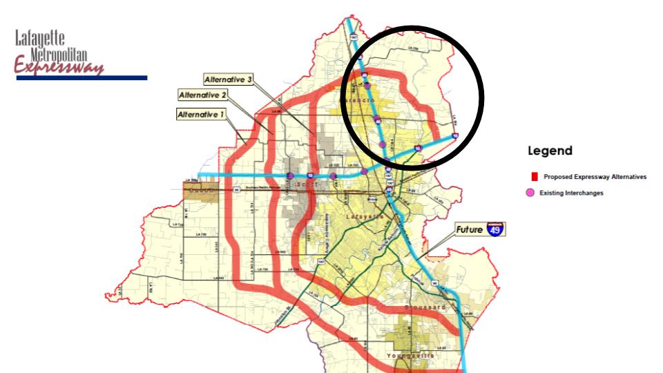
February 2005 “Study Corridor Map” from Figure 4-1 in the report “Lafayette Metropolitan Expressway, Technical Memorandum 4, Environmental Reconnaissance.” The black circle was added to the figure to indicate the segment termed the eastern corridor in these comments.


Michael G. Waldon, PhD
Resident of Lafayette Parish, Louisiana

March 15, 2019

Tuesday, February 26, 2019

Louisiana wants your opinion on a Lafayette Interstate 49 bypass, the LRX

Thursday, February 28, 2019, at the Lafayette Parish South Regional Library, the State of Louisiana will host a public hearing on their plans to build a western bypass around the City of Lafayette. The meeting will continue from 5:30 to until 7:30 pm.
Meeting Agenda:
  • 5:30-6:00 pm -View exhibits and speak with the project team
  • 6:00-6:15 pm - formal presentation
  • 6:45-7:30 - public invited to provide comments in a moderated and recorded forum
The host agency for the meeting is the Lafayette Metropolitan Expressway Commission or LMEC. Beginning almost twenty years ago, efforts and support of Lafayette civic leaders led to the creation of the LMEC by our Louisiana Legislature in 2003. The LMEC provides oversight for construction planning and financial planning for a proposed Lafayette limited access interstate bypass. They call their proposed bypass the LRX or Lafayette Regional Xpressway.
After years of work, plans have progressed, and the LMEC is seeking your comments on their Tier 1 Draft Environmental Impact Statement (EIS) which evaluates potential alternative highway corridors. The plan is for the LRX to be partially funded by tolls as part of a public-private partnership (PPP). As such, this project might be funded and built long before the costly I-49 connector (I-49 Con) project moves a shovel of dirt.  
The state will not say that the LRX is an alternative to the widely-opposed and costly I-49 Connector. I assume this is necessary to avoid loosing federal planning funds. However, the choice is clear - the LRX eliminates the reasons for building the I-49 Connector. If it is not an alternative then let's call it a substitute. If well managed and designed, the LRX substitute is financially a better deal for taxpayers. The LRX should have little or no flood impact, unlike the I-49 Con it will not cross a massive abandoned toxic site or impact our drinking water, and it will reduce traffic congestion in the city while giving rural residents new travel options. 
You can learn more about the LRX plan through the LMEC website http://www.lrxpressway.com/Their meeting announcement is available by clicking HERE.
DevelopingLafayette.com published an excellent article titled "Lafayette Metro Expressway “Lafayette Loop” Planning Continues.". And Claire Taylor published an article in The Advocate titled "Public can weigh in on Lafayette toll loop during Feb. 28 meeting." Click on the titles to read these articles.
Your comments to the LMEC and state DOTD will be accepted at the meeting. If you are unable to attend, or just want to give additional comments, you can submit your comments via their Web site (www.lrxpressway.com), or by U.S. mail to LRX Project Team, HNTB Corporation, 10000 Perkins Rowe, Ste. 640, Baton Rouge, LA 70810. Any written comments received by or postmarked on or before March 11, 2019 or 45 days following publication of the Notice of Availability in the Federal Register, whichever is later, will become a part of the record.
After the February 28 meeting I will publish an article here in Connector Comments detailing new LRX developments and comments I hear from other participants. 
I urge you to support the LRX and help save our city and parish from the disaster that is the I-49 Con.  
Alternative LRX corridor map from 2017 public meeting.

Monday, June 12, 2017

Please comment on plans for the LRX: Interstate bypass alternatives


Several past posts on this blog, ConnectorComments.org, have dealt with Lafayette bypass alternatives that would compete with the proposed I-49 Connector which proposes to build an elevated urban interstate through the heart of Lafayette. Lafayette bypasses would compete with the I-49 Con for projected traffic load, and therefore funding and priority.

Last week, June 6th and 7th, the Lafayette Metropolitan Expressway Commission (LMEC) hosted open house meetings which updated information on their plans to build the Lafayette Regional Xpressway (LRX) as a partially toll-funded interstate bypass west of Lafayette.
The LRX bypass will allow through traffic to avoid passing through Lafayette's urban core, and should relieve the city of much of its heavy truck and hazardous cargo traffic. It would also draw traffic away from some of the heaviest traffic areas of the Parish.

The infrastructure solutions firm, HNTB, gave one-on-one presentations to the public during the LMEC open house. We were told that meeting materials would be posted on the LMEC web site after the meetings. That information is not yet posted, but I have scanned the meeting handouts which are available through these links:


Public comment on LRX planning has now been requested as a part of the project's Tier 1 Environmental Impact Statement (EIS). Completion of this EIS is anticipated at the end of this year. I urge all readers of this blog to comment, share, and ask friends to submit comments. Although our state and local politicians have financial and legal constraints that limit describing the LRX as an alternative to the I-49 Con, the obvious fact  is that both would be competing parallel roadways, and funding completion of either makes it unlikely the other will ever be built! These projects are in a competition for priority and funds. Now it is up to the public to declare their preference.
The third document, the questionnaire and comment form, should be submitted to the email or postal address given at the bottom of the form. There is no set deadline for submitting public comment, but I believe it would be best to send in your comments within the next 2 weeks, and certainly by the end of June. Emailed comments should be sent to kbprejean@hntb.com


Monday, June 22, 2020

Ozone and the I-49 Connector: Why should we care?

DOTD I-49 Urban Route.
Recent local news articles on KATC and in The Acadiana Advocate  reported an LDEQ warning that on June 19 Lafayette would have high levels of ozone. LDEQ declared an Ozone Action Day for Lafayette. Why should we care about ozone?

First, high ozone levels are a risk to health, particularly among our most vulnerable citizens. Those who work or exercise outdoors are also at risk.  

Second, Lafayette has in the past been close to non-attainment for ozone, while Baton Rouge has been out of compliance. Currently all of Louisiana is considered to be in compliance with the federal standard of 70 parts-per-billion for ozone. Lafayette air pollution has improved, but there are continuing calls to make the ozone standard more protective. Non-attainment matters to Lafayette's future economic growth which could be impacted by restrictions and new requirements placed on any industry wanting to locate here. Beyond that, the most sought after companies looking for a new location are far less likely to choose a city with recognized poor air quality. Bottom line: our current good air quality is a plus for Lafayette to recruit new economic development. 

Finally, what has ozone got to do with the I-49 Connector? If you listen to Louisiana DOTD and their consultants who are writing the I-49 Environmental Impact Statement you might think ozone and air pollution have nothing to do with their plan. But, our biggest source of ozone in Lafayette is from cars. Common sense tells us that the proposed elevated interstate through the heart of our city is going to concentrate heavy traffic on city streets that lead to and from the interstate. Further, much local traffic will avoid using the elevated highway because of its limited points of access and exit. Those cars and trucks will be forced to sit in traffic on city streets. And, if the Connector has tolls, expect even more traffic forced down to city streets. Expect troubling increases in ground level ozone.

LRX Bypass Corridor Options (DOTD)
This doesn't have to happen! The proposed Lafayette Metro eXpressway (LRX) would allow through traffic and hazardous cargo to bypass the central city. For almost two decades we the taxpayers have funded planning for the LRX bypass. It is time to act and choose this alternative. The LRX would draw traffic away from easily congested urban streets and save local tax monies as city street expansions are no longer needed. The LRX would improve rather than worsen ozone pollution in Lafayette. If the I-49 Connector is built, we will be stuck with its induced traffic congestion and resulting bad air in our city for decades. Let's just not go there! 


Tuesday, June 6, 2017

Public meetings announced on the LRX: An alternative to the I-49 Connector?

http://www.lrxpressway.com/
The Lafayette Regional Xpressway, LRX, is a western interstate bypass planned to go west of Lafayette. The Lafayette Metropolitan Expressway Commission has invited you to two Public Meetings with the same open-house meeting format in two locations:


The Daily Journal of Commerce, Louisiana and Mississippi reported on July 5 last year that "it's been roughly five years since any significant public discussion of the project" and "the commission had paused planning for the bypass so as not to compete for attention with the proposed Interstate 49 Connector (emphasis added)." Work and appropriations for the LRX have been continuing, however. In January 2016 an agency meeting reported progress on the EIS and tentative selection of a preferred alternative route. 

Finally after this long delay, the public will be allowed to see what secret progress has been made over the years on this alternative routing for I-49! As always, DOTD will tell us again that "this is not an alternative I-49 route," but I think it is abundantly clear that only one, if any, of these interstate projects will be funded over the next 50 years. 


Wednesday, June 7, 2017

LRX June 2017 Open House Handouts

Last night, June 6, 2017, I attended the LRX open house public meeting at the East Regional Library in Youngsville. This evening from 5:30 to 7:30 there is a second meeting with the same format and materials being held at the  Scott City Hall, 109 Lions Club Road, Scott. This very short post is written to give tonight's attendees a heads up about what to expect, and also gives everyone not attending a bit of information.

See my Google Drive folder for this
and other handouts.
The open house format of the meeting means you may expect to take 20 minutes to an hour looking at posters and speaking one-on-one with staff from HNTB about the project that they are contracted to lead. I learned that they are doing the EIS (Environmental Impact Statement) for the project in "tiers." They plan to complete the Tier 1 EIS in December.

There were 3 handouts provided at the meeting

  1. A double sided sheet with general information
  2. An LRX Project Area and Corridor Alternatives map
  3. A comment sheet and questionnaire
The questionnaire/comment sheet can be turned in at the meeting, or sent later by mail or email. I plan to scan and email mine so that I keep a copy for my records. You can download copies of the handouts from my Google Drive folder.

No deadline was given for submitting comments, but I assume they should be sent expeditiously. 

Finally, they stated that all meeting materials would be available on their web page, Lafayette Metropolitan Expressway Commission, after the second meeting.


Tuesday, November 30, 2021

Secretary Pete: Put an immediate stop to the I-49 Lafayette Connector

Lafayette resident Ann Burruss sent the following letter to Secretary of Transportation Pete Buttigieg with copies to our Louisiana Governor, Lafayette Mayor, and Louisiana Transportation Secretary. The photos in this letter were taken by Ann earlier this month at the DOTD I-49 Open House poster presentation. 

If you feel strongly about the Lafayette I-49 Connector, you too can voice your opinion to the U.S. Secretary of Transportation by sending a letter to: The Honorable Pete Buttigieg, U.S. Department of Transportation, 1200 New Jersey Ave., SE, Washington, DC 20590. You may also email the secretary at  DOTExecSec@dot.gov.


____________________________________________________

Louisiana State Project No:  H.004273.5
Federal Aid Project No.:   H004273
Secretary Buttigieg, November 17, 2021

Congratulations to you and to the Biden administration for passing the infrastructure bill. In my volunteer work for Second Harvest Food Bank in Louisiana, I drive on substandard roads in rural parishes and I know what this bill can mean for struggling workers who commute on bad roads and bridges. Thank you for putting the needs of working people first.

I am writing today to ask that you put an immediate stop to the federal highway project called the I-49 Lafayette Connector in Louisiana. While promoting the infrastructure bill the administration talks about racial justice and equity as driving factors in projects.  Extending I-49 through the center of the city of Lafayette, Louisiana, is the exact opposite of that goal.  The planned route replaces a surface road with an elevated interstate. It’s like the 1960s and 70s all over again! As if we have learned nothing about the damage -- the permanent dismemberment -- that an interstate highway does to a city.  The I-49 Connector is racially unjust. It cements a redline through our city. It divides historically black communities from the prosperous downtown. We know better than we did in the 60s and 70s. We must do better.

The Louisiana Department of Transportation and their consultants held a series of sparsely attended open houses here recently.  They never ask the public ‘Do you want this interstate?  Do you need this interstate? If you need an interstate, where do you want it routed?’  It's always, ‘Do you like this lighting feature or that lighting feature? Do you want your children to be able to bike under this fabulous interstate, or do you want them to play basketball?’ I say “Neither.”

I and many informed citizens want this interstate to Not Be Built Here.  Instead, we want to see the LRX (Lafayette Regional Xpressway) built. The LRX will provide the first half of a loop highway around our city.  If this western loop portion proves useful and well-traveled, then an eastern portion could be built as an interstate through St. Martin Parish where they are willing and even eager to have a highway there.  The LDOT will say that an eastern highway ‘on the Teche Ridge’ can’t be built because of wetland impact - and they are correct that wetlands mustn't be harmed because of their flood storage capacity and natural value. However, the Teche Ridge isn’t the only possible eastern route. Wetlands can be avoided. Please investigate and authorize these routes in lieu of the I-49 connector.

US Census data shows that from 2010 to 2020, the population of the parishes that the I-49 Connector is supposed to serve has dropped by 15%.  The cost-benefit study for the I-49 Connector is very suspicious. How could it possibly have shown a positive cost for a highway to a rapidly depopulating area, an area that is losing its economic engine which is oil and gas production from which we must rapidly decarbonize? Accelerating coastal land loss will cause roads and highways south of Lafayette to face the open waters of the Gulf of Mexico. Additionally, the elevated route of this highway goes through a contaminated railyard and over our drinking water aquifer.

There is no reason to continue work on running I-49 through our city.  Please quickly authorize more affordable and supportable projects to the east or west of the beautiful city of Lafayette, Louisiana, my home. Thank you.

Sincerely,

Ann Burruss
110 Seville Blvd
Lafayette, LA 70503

cc:
Governor Edwards, by email
Secretary Wilson, by email
Mayor Guillory, by email


In addition to asking what kind of lights we like, the LDOT renderings add in new buildings along the route, as if prime real estate and good jobs appear right alongside interstates.  They don’t.  At best you get gas stations and storage unit facilities.  Please consider promulgating rules to prevent fanciful projections in renderings.  All transportation departments should show only exactly what they propose to build.


Do you want your children to walk, play or bike under an interstate highway?  I have never seen these activities happen under interstates anywhere in our country because parents know better.  Under an interstate is air pollution, soil pollution, noise pollution and danger from falling objects.  Diseases like asthma, chronic stress and depression from sleep disturbance will develop in nearby populations. Please don't visit these traumas on more of our people.


Photographs from posters presented by LDOT and consultants at the November 2021 open house series in Lafayette, Louisiana.


Wednesday, May 25, 2016

The I-49 Lafayette Western Bypass Option: The "Lafayette Regional Xpressway"

One bypass alternative for Lafayette has been under study by the DOTD since 2003. At that time, the Lafayette Metropolitan Expressway Commission was created by the Louisiana State Legislature. They are commissioned to study alternatives for the Lafayette Regional Xpressway, or simply the LRX. The LRX would create a bypass loop which begins in the south at Highway 90 / I-49 south of Broussard, has a major interchanges as it crosses Highway 167 (Johnston Street) north of Abbeville, and I-10 between Duson and Scott. This portion of the roadway would be very roughly 25 miles. The bypass would then continue north and east for roughly 20 miles to return to I-49 north of Carencro. An eastern bypass leg of very roughly 15 miles would run south east from north of Carencro to I-10 west of Breaux Bridge. Total length of the Lafayette Regional Xpressway bypass would then be very roughly 60 miles.

 The Lafayette Metropolitan Expressway 2005 feasibility study’s rendering of a proposed expressway. (Photo: Lafayette Metropolitan Expressway)


At an estimated cost of $760 million, the cost per mile for this roadway is under $13 million per Interstate mile. The 5.5 mile Lafayette Connector project which now has cost estimates of over $1 billion before toxic waste removal and flood mitigation have even been considered. This gives the Connector a cost that will greatly exceed $182 million per mile. 


More information is available at

Lafayette Regional Xpressway Project Website  http://www.lrxpressway.com/

The Advertiser, October 23, 2015,  Citigroup and the Lafayette Loop — what's next?
 http://www.theadvertiser.com/story/news/2015/10/22/citigroup-and-lafayette-loop/74359164/

The Advertiser, October 23, 2015,  Is Lafayette ready for a traffic loop?
 http://www.theadvertiser.com/story/news/2015/07/01/still-loop/29588975/

Lafayette Regional Expressway Rendering
Source: http://www.lrxpressway.com/

Tuesday, June 27, 2017

Citizens comment on the environment, energy, ethics, and other topics - June 20, 2017, Lafayette City/Parish Council


The Lafayette Consolidated Government Council meetings are open to the public, and citizens may make comments within the scope of each agenda item. Furthermore, 5 minute comments on any subject are taken monthly at the second monthly meeting. This month, June 2017, eight citizens brought issues before the Council (click for video of all comments) during the June open comment period.

The following is a list of speakers and the subject of their comments. Links in the list will take you directly to the start of each citizen's comment.
  1. Simon Mahan - good government, and making it easier for citizens to participate and comment
  2. Michael Waldon - the Chicot Aquifer, contamination of Lafayette's drinking water source, and contamination at Lafayette's abandoned UPRR railyard, and citizen recommendations letter
  3.  Kim Goodell - Civic duty, Watermark Alliance, Chicot Aquifer protection including wellhead protection, an update on the ongoing lawsuit concerning railyard contamination, and citizen recommendation letter
  4. Andrew Hebert - the conflict of interest inherent in our city/parish council districts
  5. Kasandra Ford - Renewable energy, Chicot Aquifer protection, drinking water testing, railyard contamination, risks from I-49 Connector plan, and Indivisible Acadiana
  6. Matthew Isaac - Protection of the Chicot Aquifer, drinking water testing, railyard contamination, and citizen recommendations
  7. Dennis Sullivan - Opposition to the I-49 Connector plan, the LRX
  8. Lillian Espinosa-Gala - Electric vehicle charging stations in Lafayette, noise and fumes from the I-49 Connector, the LRX, and hurricane evacuation from Port Fourchon to Houston
Next month open comments should be scheduled during the July 25, 2017 meeting, and we hope that some of the issues brought forward this month will be addressed by Council members at that time. Immediately following that July 25 meeting, the Council will initiate their budget review process which should lead to significant citizen comment.

Video of the entire 3 hour meeting which was recorded by the Acadiana Open Channel Community Media may be viewed at http://www.ustream.tv/recorded/104993499
A pdf file of the meeting agenda is available here.

Tuesday, October 23, 2018

The I-49 Boondoggles

What is a BOONDOGGLE? Wikipedia tells us it refers to
projects involving large numbers of people and usually heavy expenditure, where at some point, the key operators, having realized that the project will never work, are still reluctant to bring this to the attention of their superiors.  
Public opposition to routing I-49 through the heart of our city goes back at least to 1992, and for years now, Lafayette residents have recognized that the government project now being called the Lafayette I-49 Connector (we call it the I-49 Con) is a prime example of a wasteful government boondoggle (for an example of public comment read "Why the I-49 connector won't work" published May 27, 2016 in the Daily Advertiser). The public has been assured many times that if there is significant public opposition to the project it will never be built. Yet, the I-49 Con continues spending tens of millions of tax dollars on studies and design that will never be used for a footprint through the heart of the Lafayette.

Sarah Palin holding Nowhere Alaska t-shirt
Sarah Palin holding a T-shirt related to the Gravina Island Bridge.
Credit: Bob Weinstein via Wikimedia
Regardless of how wasteful the project, politicians from both sides of the aisle often find it hard to oppose tax funded boondoggles. Perhaps this is because of the inevitable cycling back of a percentage of the money into campaign contributions. Even some of the most conservative politicians seem unable to pass up wasteful government boondoggle projects. Do you recall the support of Sarah Palin for federal funding of the Gravina Island Bridge commonly referred to as the iconic "Bridge to Nowhere?"


The national Public Interest Research Group (USPIRG) published their 2018 list of US interstate highway boondoggle projects. If built as proposed, these boondoggles would waste tens of billions of our federal transportation tax dollars. And, even if these boondoggles are never built, billions will be spent on their planning and design before public pressure and simple rationality end their useless authorizations.

Although our own local boondoggle, the I-49 Con, did not make the USPIRG list this year, its sister project in Shreveport, the Shreveport I-49 Inner City Connection did make 2018's national list of worst boondoggles. Better luck next year to our own I-49 Con! If USPIRG accepts nominations in 2019 the I-49 Con will have my vote.

It is important that our political representatives hear from their voters about stopping these federal transportation boondoggles. If we don't speak up the only voices our leaders hear come from paid lobbyists representing the corporations and contractors who are hoping to continue getting design and construction contracts.

We do know that at least some of our leaders are hearing us. On October 17, 2018, One Acadiana hosted a 3rd Congressional District Candidate Forum. All seven remaining congressional candidates running in the November 6 general election participated in the forum:


Several of the candidates spoke to the forum in general terms about our need for improved infrastructure and the need to eliminate wasteful federal spending. However, two candidates spoke directly about problems with routing I-49 through the center of Lafayette. Congressman Clay Higgins noted that routing the interstate footprint through the central city would displace or impact a large number of private property owners. He concluded that an actual footprint for the project still needs to be selected. Candidate Mimi Methvin cited further problems with the central city route including its planned passage through the highly contaminated former railyard site. Furthermore, she noted that today urban experts and planners recognize urban blight in many US cities has been caused by the past construction of inner-city interstates.

Do you agree that the Lafayette I-49 Con is one more federal boondoggle currently wasting many tens of millions of tax dollars on design of a route through the heart of our city? Do you agree that, as now planned, the I-49 Con should never and likely will never be built?

If your answer is yes, I urge you to contact your chosen 3rd district candidate. Tell him/her of your opposition to the currently proposed central I-49 route. Ask your candidate to support planning for one of the much less costly and less damaging alternatives bypassing Lafayette to the east along the Teche Ridge or west following the plan for the Lafayette Regional eXpressway (LRX). In addition to saving federal and state taxes, either alternative also involves much lower cost to our local governments, reduces risks to property and health, and eliminates most impacts to flooding and traffic congestion inherent in the I-49 Con planned route through the heart our city.

Mike Waldon, PhD
October 23, 2018 

Saturday, July 2, 2016

Airport angles and increased risk

SUMMARY: Because this is an unusually long post, you may wish to skip first to the SUMMARY at the end of this post before reading the entire post.

A LOT has been written on the topic of "things you just should never do."  One of these "never do" actions is to build tall structures next to your airport. This is precisely the DOTD plan for extending I-49 through Lafayette.

In an earlier post I talked in general about the problems associated with the Connector plans relative to the Lafayette Airport. In this post. I want to get down to specifics.

Figure 1.  Google Earth image of the northwest end of runway 11-29 in relation to the intersection of Evangeline Thruway, University Ave, and Surrey St.  

Federal safety guidance defines the maximum height that objects should not exceed in the vicinity of airports. This definition is based on a number of imaginary surfaces through which no objects sitting on the ground should penetrate. Keeping aircraft above the imaginary surfaces, and all terrestrial objects below, provides for safe landings and takeoffs.

The lowest of these imaginary surfaces, the primary surface, is a rectangle at the elevation of the runway. The primary surface extends 200 feet beyond each end of the runway and 500 feet on each side of the runway centerline. Beyond each end of the primary surface there is an approach surface. The approach surface begins at the primary surface elevation and rises, for runway 11-29, at a slope of 34:1 (termed a 3% slope). That is, for every 34 feet of center-line distance the surface rises 1 foot.  At their intersection, the width of the approach surface is the same as the primary surface, 1000 feet, and is centered on the runway center-line. The approach surface widens to 4000 feet at 10,000 feet ground distance from the primary surface. That is, the approach surface width is 1000+0.3x, where x is the ground distance along the center-line away from the primary surface. There are other defined surfaces (transitional surface, horizontal surface, conical surface), but only the primary and approach surfaces are relevant to the issue of runway displacement for 11-29.

The 2002 Final EIS asserts in numerous locations that the Lafayette Regional Airport runway 11-29 will need to be displaced 350 feet to the southeast toward Bayou Tortue and Cypress Island Swamp from its present location to meet minimum federal safety requirements for an approach surface slope of 34:1 and a 17 foot margin of safety (FEIS exhibit 4-4). While the FEIS makes the assertion that the 350 foot displacement is required, it does not show the underlying data or rationale needed to support the claim. I have therefore been forced to attempt to recreate these calculations. My calculations, however, do not agree with the conclusion in the FEIS. Lacking documentation of the FEIS methods, I conclude that the 350 foot assertion is likely in error.

A history and general information about the Lafayette Regional airport may be found in the Wikipedia article titled "Lafayette Regional Airport." Additional information on the airport AirNav.com. That web page also includes a link to a useful Airport Diagram. The diagram shows that runway 11-29 is 5401 feet long and 148 feet wide. Elevation at the northeastern end (designated 11) is 37 feet; elevation at the southeastern end (designated 29) is 35 feet.

Figure 1 is an image captured from Google Earth of the northwest end (designation 11) of runway 11-29. It illustrates that the runway does end quite close to the current highway. Measurement shows that the runway currently ends roughly 600 feet from Evangeline Thruway (Hwy 90), and roughly 700 feet from the intersection of the Evangeline Thruway, Surrey St, and University Ave.

Figure 2. This image is extracted from the FEIS Plate 2a2. North in this figure is to the right, and distance along the horizontal extent of the roadway in hundreds of feet is given on the horizontal axis; elevation in feet (NGVD 29 datum) is plotted on the vertical axis. The roadway is charted as the solid black line. The 40 foot elevation is highlighted by a dotted red line. Peak roadway height at the interchange is estimated to be 45 feet. 


Finally, it is necessary to estimate the height of objects above the roadway. This could include signs, streetlights, and aircraft warning lights. The FEIS does mention this, and suggests that special signage and lighting may be necessary. Thus, I will assume that the height of the vehicles on the roadway will be the tallest objects above the roadway. There is no Federal vehicle height requirement for commercial motor vehicles (CMVs). Most eastern states, including Louisiana, set a CMV height limit of 13.5 feet on most highways. Louisiana does allow heights of 14 feet on designated highways, and oversize permits can be routinely issued for heights up to 16 feet 5 inches. Without specific guidance from the Louisiana DOTD, it is unclear what height should be assumed. Here, I will simply assume a maximum height of 15 feet for all vehicles and objects on the roadway.

Assuming the peak height at the interchange structure controls the required runway displacement, the calculation of length for the approach surface is now straightforward.  The interchange height plus object height has an elevation of 60 feet (45+15). Adding the FAA 17 foot margin of safety gives a total elevation of 77 feet. Subtracting the runway height which defines the primary surface elevation then gives a height of 40 feet (77-37). At a slope of 34:1, the length of the approach surface to the primary surface is 1,360 feet (34x40). At this point along the approach surface, the approach surface width is 1408 feet (1000 + 0.3x1,360), or 704 feet on each side of the extended runway center-line (Figure 3). Adding the 200 foot width of the primary surface at the end of the runway gives a total distance form the peak of the interchange of 1,560 feet. The present distance is estimated to be 700 feet, so the total runway displacement required would be 860 feet (Figure 4). This is 510 feet longer than the value asserted in the FEIS. This difference significantly brings into question the economic, environmental, and engineering feasibility of the displacement.

Figure 3. The more northern half of the new approach surface (black outlined trapezoid) begins with a width which is 500 feet on either side of the extended runway centerline, and 200 feet beyond the new runway end (orange line). The distance to the centerline extends to 704 feet at the proposed elevated interchange.

The calculated extension will require very roughly the destruction of 45 acres of the Cypress Island Swamp west of the airport (Figure 4), and more if embankments in the swamp must be longer than existing embankments. This considerably exceeds the 5 acres estimated in the FEIS (p 4-92).

(a)

(b)
Figure 4. The upper figure (a) shows the current airport runway at the southeast end of runway 11-29. The lower figure (b) is the same image with an 860 foot length of runway and associated area is copied onto the current end of the runway. The original image was printed from Google Earth. 
Construction would require significant fill, and consolidation of the underlying wetland soil will further aggravate the existing problems of soil stability at this end of runway 11-29.  The FEIS on page 2-10 states that "a prior runway extension of about 200' constructed in 1967 has subsided up to approximately four feet and has been removed from service." This fill will encounter even greater engineering challenges.

The new extension into the swamp will need to deal with a very significant drop in elevation (Figure 5). As much as 35 feet of fill will be required for the extension. If earthen embankments are used at the sides of the filled area, considerably more than the estimated 35 acre area of wetland may be required in order to accommodate the more extensive embankment areas.

(a)
(b)
Figure 5. In (a), the center line of the runway (red line) is extended at the southwest end of runway 11-29. The green bar indicates 860 feet from the end of the center line, and the thin white lie crossing the center line is 860 feet from the runway end. Figure (b) graphs elevation along the center line from 39 ft to 4 ft.  


Options: What are our options? They include:
  1. The No Build alternative should always be considered. If the currently planned I-49 Connector project is abandoned, it could be replaced by upgrades to the current Evangeline Thruway, and bypass to the east along the Teche-Ridge, west using the LRX alignment, or both to form an urban loop.
  2. Build the connector project as decided in the FEIS and ROD, and extend runway 11-29 as required to meet minimum FAA guidelines. This will require land acquisition and a Corps of Engineers wetland permit. Likely this alternative will further require wetland mitigation and flood mitigation.
  3. Build the connector project as decided in the FEIS and ROD, and request an FAA exemption from airport approach obstacle safety requirements.
  4. Abandon use of runway 11-29.
  5. Revise the design in of the selected alternative to eliminate roadway elevation in the vicinity of the 11-29 runway approach surface.

SUMMARY: The I-49 Connector FEIS identified unacceptable risk due to failure to meet FAA flight path obstruction guidance, resulting from the proposed interchange construction adjacent to the Lafayette Regional Airport. Without documenting calculations or rationale, the FEIS stated that in order to meet these minimum safety requirements, airport runway 11-29 would need to be displaced 350 feet southeast toward Bayou Tortue and the Cypress Island Swamp.

My calculations, based on FAA guidance, arrive at runway displacement considerably longer than that presented in the FEIS. Here, following FAA guidance, I calculated that the required displacement is 860 feet. This significant difference brings into question the economic, environmental, and engineering feasibility of the displacement. Impact of this displacement on flooding, wildlife, and wetlands should be carefully addressed and documented by DOTD.

The public attitude toward airport safety should always be conservative and circumspect. The Airport's 1975 Master Plan concludes "Conditions at the airport's periphery make expansion of its land area difficult or expensive or both." Even beyond the impacts of runway displacement discussed above, it is simply inappropriate to choose to construct any tall structures on the periphery of our airport which is already severely constrained at its location. Tall structures like the University and Kaliste Saloom interchanges constrain future airport runway alignment adjustments, and impact the ability to meet current requirements and future safety requirements should FAA guidance on safety margins or approach slopes change for any reason.