Lafayette Parish flooding will be increased along the Vermilion River and its tributaries by the Connector project.
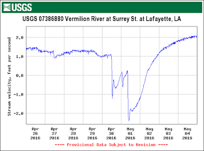
A big rainstorm occurred in Lafayette beginning April 30, 2016. Look at this graph of Bayou Vermilion water velocity at Surrey Street - the negative velocity (up to 2 feet per second) means the Bayou is flowing backwards fast! This has important implications for flood control and planning in our community. Much of our flooding happens from water stacking up in the Bayou with no way to flow south. Drainage "improvements" bringing higher peak flows into the Bayou south of the city can raise the stage so much that this downstream water actually flows north and creates a "water dam." Now, coulees draining the storm water from city neighborhoods must either fill the Bayou to higher levels (stages), or back up with no outlet. Many flood planning computer models ignore this "backwater effect." That's OK in most other places in the US, but literally disastrous for flood planning in South Louisiana.
Video: Backwater in Coulee Mine Branch, Lafayette, La.
NOW - What action do you need to take? When planners for new projects say they have done careful computer analysis and determined that no new flooding will result from their project be very skeptical. Ask if they took backwater flooding into account for both their project near and upstream of their project. You will likely be met with ignorance, arrogance, and condescension, but do persevere. What projects? Well the I-49 Connector comes to mind.
AND - What analysis of flooding impacts did DOTD provide in their 2002 EIS for the I-49 Connector? Basically nothing. Their plan is to provide the very efficient drainage required by interstates, and route the water to the Vermilion either directly, through existing drainage structures, or using very large pumps. No accounting for flood impacts from this massive increase in impervious surface is even attempted. No proposals have been made to build stormwater retention/detention basins for the project. In the EIS, no consideration was given to the residential and street flooding that will result from the project. It is likely we will experience heavy rain during hurricane evacuation, and this planning deficiency is all the more alarming when hurricane evacuation is considered.
There is a history of DOTD flood and drainage design along US-90 and I-49. During a heavy rain event in 2001, cars went underwater on Hwy 90 east of Broussard where Hwy 92 crosses US-90. Cars had to be routed over to the Teche Ridge area on Hwy 31. In the April 30 - May 1 rain storm The Advertiser (1) reported rainfall of over 10 inches. While this is large, Louisiana at times receives over 20 inches of rain in a day. Occurrence of flooding of the I-49 roadway just north of Lafayette is an alarming sign that the I-49 corridor is not well designed for hurricane or flood evacuation.
| Photo: The Advertiser (1). |
Further, some DOTD plans for the I-49 Connector call for excavating underpasses or even depressing large parts of the interstate roadway itself. As local citizens know all-too-well, below grade underpasses in South Louisiana have a problematic history (2). Reliance on large pumps makes travel during heavy rain events reliant on maintaining electric power at the pump stations (assuming electric pumps are used), or reliability of diesel-driven pumps and fuel delivery (if diesel power is selected).
1. The Advertiser, May 2, 2016, Flooding Sunday some of the worst seen in years http://www.theadvertiser.com/story/weather/2016/05/01/-49-close-due-flash-flooding/83787580/
2. KLFY, March 18, 2016, University Ave underpass near Cameron St OPEN after flooding
http://klfy.com/2016/03/18/university-ave-underpass-near-cameron-st-open-after-flooding/
